
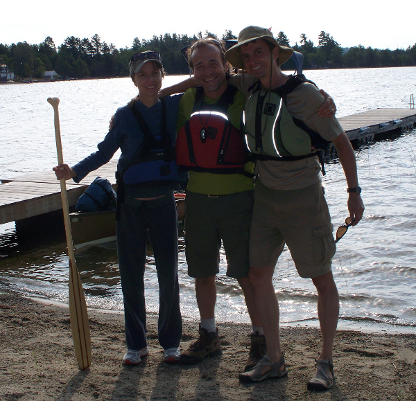
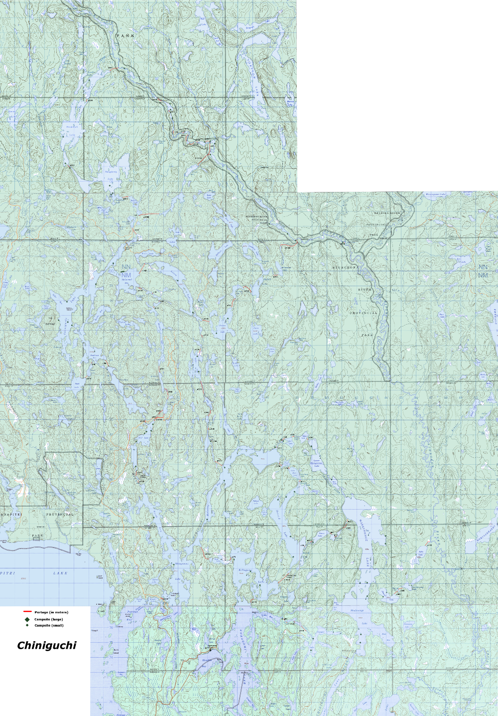
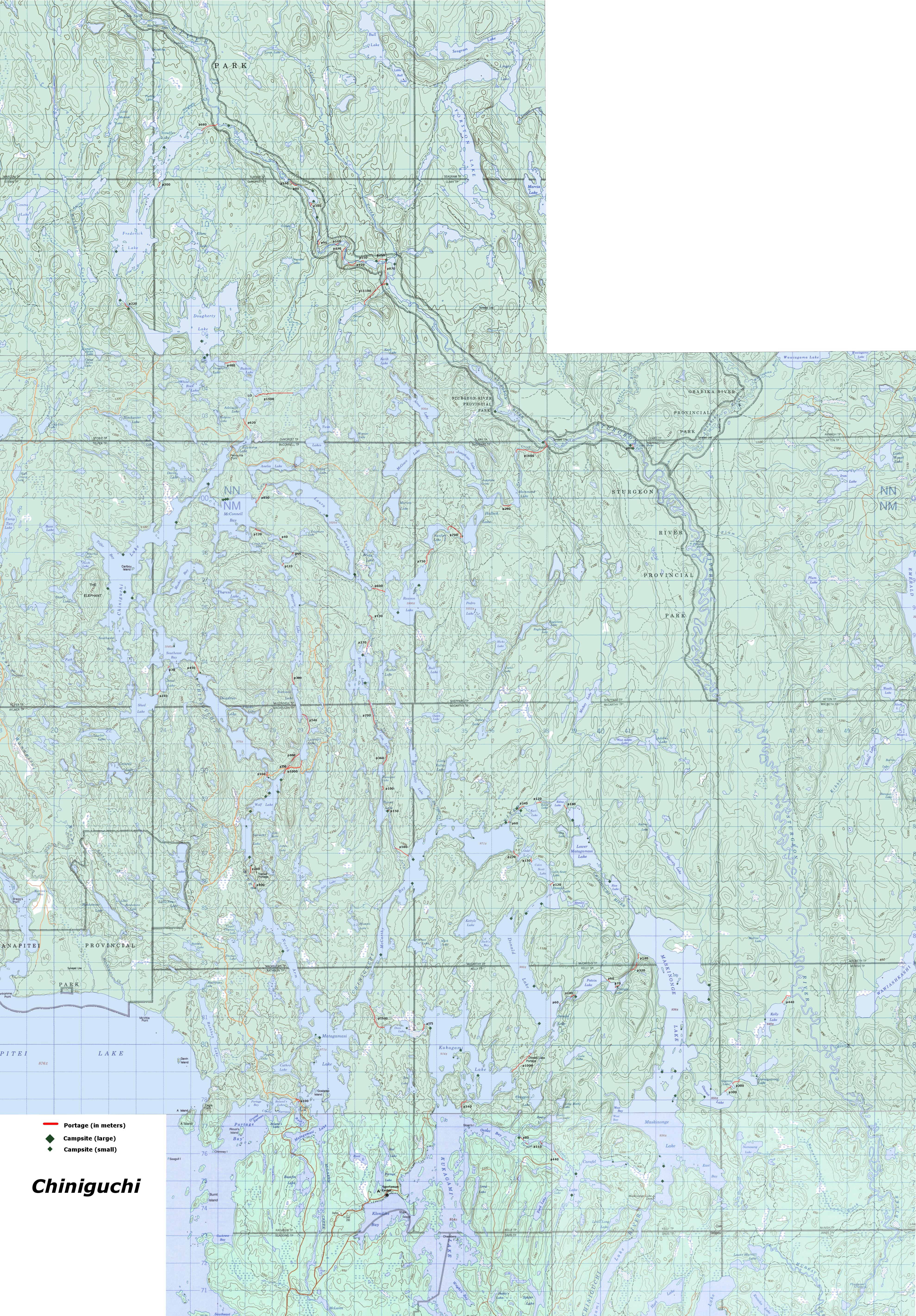
Chiniguchi Canoe Trip - July 2012My sister and brother-in-law, and I, spend a week together every year doing the "Big Canoe Trip." We've been many places over the years, especially Killarney, which we've paddled basically through every lake and bit of water there is! So for 2012, we decided on something different in the Chiniguchi area, which is south-west of the Sturgeon River, between Temagami and Sudbury. I had done one trip there in the Fall of 2010, which was fantastic. I've always been biased toward reservation canoe parks over crown land, due to concerns about over-use. But this area is beautiful, and surprisingly unspoiled once you get a portage or two in. As long as you are prepared in advance to spend 30 minutes a day cleaning camp sites, it's worth exploring this area. An added benefit of tripping in crown land is that you do not have to worry about making reservations in advance, there are no fees (except on the Sturgeon River, which requires paid permits), and you can change your route on the fly. My advance concerns about this crown-land area being crazy-busy in peak canoe season turned out to be completely unfounded, and overall we saw less people than some of our trips into the remotest areas of Killarney. Large-scale maps of ChiniguchiAs part of the planning for this trip, I scoured online resources and maps. Unlike reservation parks, the camp sites and portages are not available in a single published map: you have to do a bit of work to prepare for a trip in this crown-land area! During the long winter months waiting for our trip, I compiled all the information I could find into a single large-scale map of the Chiniguchi area, using public-domain Canadian government maps. The two maps below show every camp site and portage in the area (if you know of additional information for this map, please feel free to e-mail me at: 'dan at deepnettech dot com'.) small-scale detailed area map covering all routes below, with portages and campsites noted: 3 meg. Large-scale detailed area map covering all routes below, with portages and campsites noted: 30 meg. The best place to get information online about the Chiniguchi area is: ottertooth.com. Farther below, you'll find a large list of several other routes we considered, which may appeal to some travellers. Our trip: Kukagami, 112.5kmDay 0, Friday. July 20, Toronto to Motel
I drove to Toronto for noon to pick up my sister and husband. From there, we drove north to the Norvic Motel off highway 17, not far from the dirt road north to Lake Kukagami. We figured we'd be arriving late, and the cheap motel would be fine for one night, allowing for an early start the next day. Man, what a mistake! The Norvic was a stinky noisy dive. We got completely stuffed up from the moldy smells, which did not improve for days. We had considered staying at the Sportsman Lodge, but that meant another hour of driving at night on a dirt road, and the cost would have been very high. In the end, we got up early and went to the lodge for breakfast, from which we'd be starting our canoe trip. The lodge is one of the nicer cottage resorts I've seen, and breakfast was very good. For future trips, we'd probably just plan to arrive at dusk, and take a camp-site in the north end of Lake Kukagami. The (new) owners of the Sportsman Lodge are very nice people, and parking your car there is safe and affordable at $5/day. Click here for driving details to get to the lodge from highway 17. After breakfast, we packed our canoe, enjoying the bright sunny weather, and headed out. Day 1, Sat. July 22, Maskinonge Lake
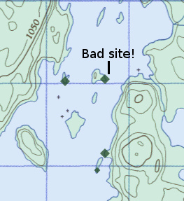
Our plan for the first day was to travel east through Carafel Lake to lower Maskinonge. These lakes are all boat-accessible, with cottages on Kukagami and Maskinonge. We expected this, so we were not surprised by the boats and fishermen on Carafel. The presence of boaters on these lakes compelled us to carry on a bit farther that day, so we avoided the southern-most sites on Maskinonge and carried on to the island sites 4 km north. By that point, we were tired, and the winds had picked up, so we stopped at an obviously unoccupied site (several others had campers on them.) After beaching the canoe, we walked the path into the site, to be greeted by a disappointing "hunter's" camp site: stripped of trees and bare, tattered tarps spanning trees, and garbage on top of garbage everywhere. A depressing sight for sure, but we were tired, so we made the best of it. After an hour of cleaning the site and re-digging several latrines (complete with toilet seats), we felt like we could bare staying there. Thankfully, we didn't see any other sites quite this bad for the rest of the trip. Unfortunately, staying on boat-accessible lakes in crown-land usually means hunter camp-sites like this. There's no doubt someone thought that all this structure they built was a positive addition, but leaving a mountain of garbage is just unacceptable and sad.
For the duration of this trip, I settled into a usual pattern on arrival at our camp sites: This would take 30 to 60 minutes, and then I felt better! Besides... it was my small contribution to improving this beautiful area. I would definitely not travel here without a full metal folding shovel though. Day 2, Mon. July 22, to McCarthy Bay
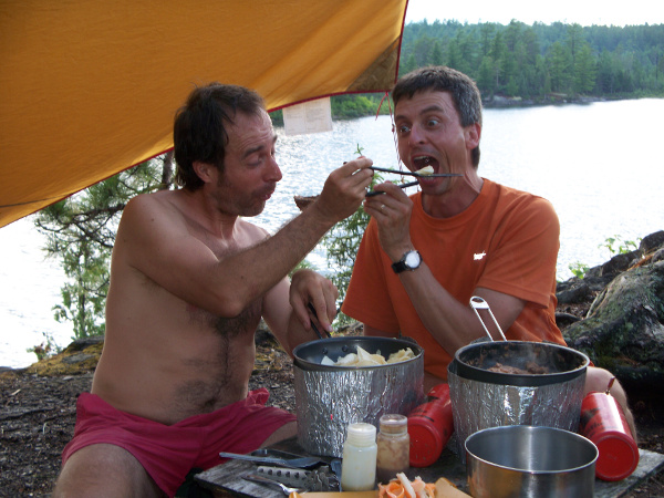
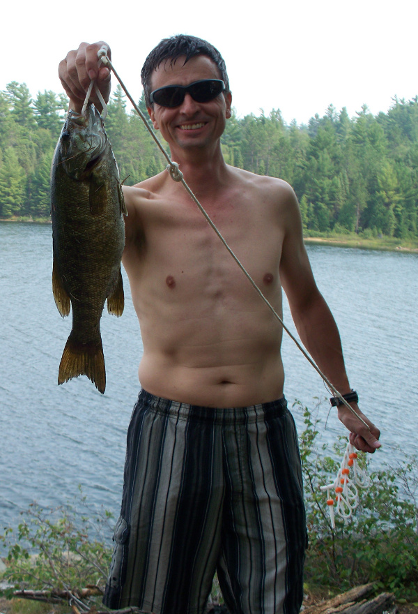
We had originally planned to stay at a camp site along the Chiniguchi River between Edna and McCarthy Bay, but the water levels were very low, making the rough open sites somewhat unattractive. So, we carried on and took one of the island camp sites at the top of McCarthy Bay. Although this lake is boat accessible and there are a couple of modest cottages in the north part, it is very 'canoeist friendly', and the camp sites were unharmed, and clean. The southern part of Matagasami Lake has many cottages, but once you get into the North Arm, it is scenic and natural. We arrived early enough to enjoy some swimming off the excellent deep shoreline, and I got to fish a bit as well. My sister does not fish at all, and Jorge only does so reluctantly (he didn't bring his Spongebob rod and reel on this trip!) I was able to quickly catch us up a couple of large bass for dinner as well.
As I cleaned up the fish away from the camp site on the point into the bay, a boat that had been fishing in the area for hours passed day. Of course I presented my fish, caught within 30 minutes right from the shore of the camp site with a plastic grub! Some reluctant kudos were offered from the jealous boaters as they continued on. We heard the strangest screechy bird calls from across our site along the opposite shore, and had assumed it was an eagle or hawk's nest. But we saw two adult heron's flying over from the area to the northern tip of our site later on, and they made the same grating screech. We guessed that the calls were chicks in a nest, although it seemed too late in the season for hatchlings. I've seen hundreds of herons over the year, but had never heard their call. A bit of a let down, to be honest, for such a graceful bird! Day 3, Tues. July 23, to Evelyn LakeI had received just prior to this trip a small weather radio. I've never brought a radio before, but liked the idea of these cheap and simple devices. They are programmed to search for these special weather forecast frequencies, so all you have to do is turn it on and listen. This worked surprisingly well, especially for such a lower powered device. There was one drawback though: no matter where we were, this radio would only pick up the station if you held it in the most awkward stance, at the most annoying spot in the camp site. I was impressed that such sophisticated AI could be built into a simple $20 radio, since it immediately stopped receiving as soon as you put it down, or tried to sit comfortably. But as long as you held it "just right", it did work extremely well. In Canada, the weather broadcasts are repeated in English and French, and are about 10 minutes long (including marine forecast.) So it does take a bit of effort to hear the relevant forecast. The radio proved helpful that day, as it was grey and overcast, and a big rain storm was coming in. So, we decided to only partially pack up, keeping one tent up to wait it out. As we did so, we could see a group of young girls packing up their site 1 km south of us, heading our way. We flagged them down as they passed, and warned them about the coming storm. Just then, the winds picked up and a torrential rain started coming down: the girls made it safely to an island 500m north of us (I think they wanted to be on their own, rather than wait out the storm with us.) After the storm subsided, we got out and packed up, smiling at the sounds of camp songs across the way, as the girls packed up as well. I like seeing well organized youth groups while on my trips: I've never had a bad experience with them, and it's good to know that an appreciation for our wilderness lands is being spread to younger generations.
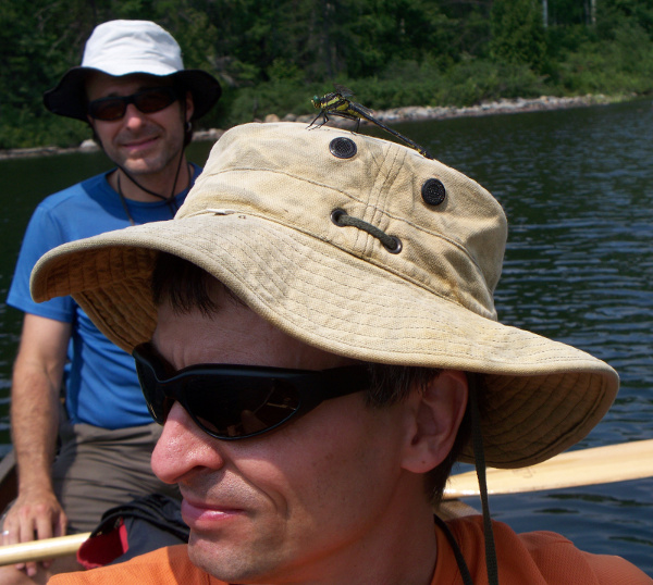
We now were going to begin the traditional "Laura Lake Loop", which I had done two years back, although in the other direction and with higher water levels. The portages in Chiniguchi are surprisingly well maintained for crown land. At worst, you have to deal with some blow-down and occasional challenges finding the trails. We had planned on camping farther north on Laura Lake this night, but the weather was starting to look ugly again, and our trusty radio said more thunderstorms were on the way. So we stopped at Evelyn Lake, staying at the elevated island site on the east side. We had just managed to get our tents up when the rain and lightning started, so we were able to wait out the storm. 30 minutes later, the rain stopped and the sun came out, bringing with it intense humidity and heat. Some other canoeists passed by then, looking soaked to the skin and beaten. As I sat in camp in the increasing heat, suddenly large fish started jumping crazily in the lake 50m off shore! Changes in barometric pressure always seems to do this, probably due to the bugs blown onto the now calm water. I couldn't reach the jump spots from shore, so I jumped into the canoe and headed out. Within 30 minutes, I had caught a nice 18" bass for dinner. Day 4, Wed. July 24, to Chiniguchi Lake
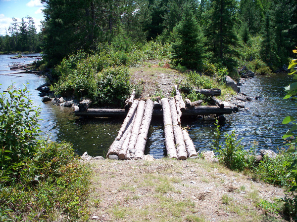
We woke to another great sunny day, although surprisingly cool from that point on in the trip. The journey here would take us north and west, across the dreaded 850m McConnell Bay portage. When I had done this portage a couple years back, there was an unavoidable 200m swampy section in the middle that, combined with cold Fall rain, proved unnerving at best! I cautioned everyone to expect the worst, especially with the day-prior's intense rain. At the narrows at the very bottom of Laura Lake, is a cut across an old (closed) logging road. We decided to stop and have lunch there. Since I was last in this area, hunters have built a log bridge across the water. The MNR does not allow this, and I was mighty tempted to destroy the bridge. But I did not have the right tools for the job, given the serious construction. Next time I'll bring dynamite... ya, that's the ticket! Like all hunter camp sites, this was a barren disaster, with rusted out kitchen items, ruined tarps, beer bottles, and broken glass. It did have a plastic table and chairs still useable, making for a comfortable lunch I suppose. I would have preferred an unspoiled rock face overlooking the water though.
The winds were picking up, so we would have a tough paddle north on Laura Lake. We stopped at the island site 1/2 way up for a break, then carried on to the dreaded portage. I steeled myself for the worst, and we set off. But when we got to the wet swamp, I was astonished to find it completely passable, and only a bit spongey! We simply walked across, not having to fear hidden mud sinkholes up to your neck. It had been a dry summer so far, as witnessed by the low water levels, so I guess the conditions at this section vary a lot. The beach sites on McConnell were empty, but we pushed on, hoping to get a camp site on Chiniguchi, so we could sneak in a hike up to "The Elephant". We took the site at the point of Telfar Bay, which I had stayed on before and is very nice. But, by the time we got there, looking out across the white caps, we decided to stay put and not do the hike that day. I did catch another nice 16" bass though from shore. We didn't see any paddlers or boats in Chiniguchi that day or the next morning. Day 5, Thurs. July 25, to Wolf LakeWe woke to a grey and rain-threatening day with fair winds, so we pushed on and didn't stop to hike The Elephant. That's two trips now that I've passed that hike up... next year! We paddled south to Wolf Lake, and stayed at the northmost camp site set into a steep hill side, as there were other campers on the lake. We did see a small bear on the east shoreline of Dewdney, scrounging in the bushes. We had wondered if the complete lack of blueberries this summer due to no rain, would be a problem for the bears. This one seemed pretty desperate to come down to the shoreline.
Dewdney and Wolf are beautiful lakes, very reminiscent of parts of Killarney, with some exposed quartz rock faces. Sadly, mining interests in the area may be re-opening, which would destroy it. The government's recent changes to the Environmental Act will make development of this area far easier to start, since ecological assessment requirements have lessened, allowing mining without consideration to the impact. I was just a teenager when activists in the 80s and 90s successfully fought off lumber development in some Temagami old-growth forests. If mining in Wolfe Lake ever becomes a reality, I think I would have to stand up and fight to save this area. Being a vocal advocate is one thing, but clearly not enough to save this important land. Sometimes you have to fight to defend what you believe in. For now, it appears that the economic value of the minerals at Wolfe Lake are not enough to justify the business development: let's hope it stays that way.
After my usual hour of cleaning the camp site and re-digging thunderbox privies (note to girls in youth groups: plastic tampon applicators do not decompose! Pack them out, or use paper ones!), I cast my rod into the rainy drizzle. And... every single cast for the first 30 minutes brought in a bass, without exception! It was fun, but they were all too small to keep. Eventually, I got a couple good 15" keepers for dinner, but it was tons of fun. That's the kind of fishing my kids have always enjoyed... insta-catch and release. This camp site appeared well used, as evidenced by a very brave ground squirrel that kept sneaking into our food bags. Just three feet from us, it crawled into our dirty dishes and tried to make off with a spatula! Day 6, Fri. July 26, to Matagamasi Lake
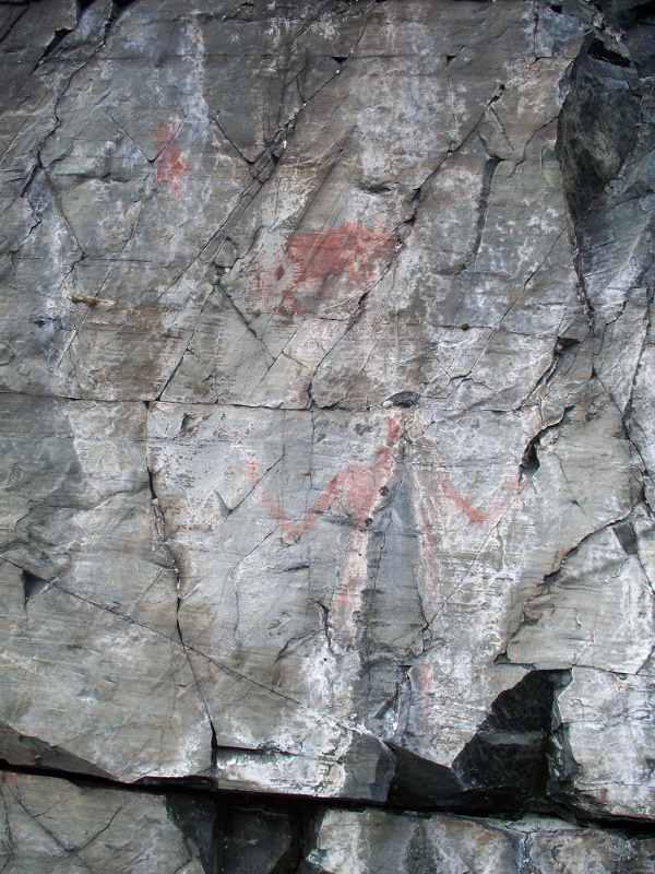
I was looking forward to this stretch of the trip so we could see the native pictographs along southern McCarthy Bay. Most pictographs I've seen are barely visible, requiring some creativity to imagine in full. These ones are very prominent, and easy to make out. After the portage from Wolfe to Matagasami, you're back into boating and cottage territory. But, the 'arms' have very few cottages, with most being in the southern bay. Despite this, we really did not see very many people at all, cottagers, boaters or paddlers. This really surprised me, as I was prepared for zoo-like conditions given the time of year. By comparison, the French River in prime-time is insanely busy, sometimes very difficult to find unoccupied camp sites. We ended staying at the same island camp site we had chosen on the way south, since it was so nice. The fishing was not as good and easy as before, which goes to show much depends on the weather! Day 7, Sat. July 27, to Donald Lake
For the return section of our loop trip, we portaged to Donald Lake via Gold and Colin. These two small lakes were pretty gems, and in the future I would probably try and find a way to camp on them if I could (there did appear to be some rough camp sites visible from shore.) But Donald is another Killarney-like lake, with some soaring cliff faces in the north part. We wanted to shorten our last day out as much as possible, so we continued south as far as we could. Unfortunately, the Lake was very busy with many camp sites taken. We ended up at the south-most camp site on the west shore, which was very open but OK. It was surprisingly cold that day and the night prior, so some shelter from the wind would have been nice, but not possible on this high open site. This was the only site at which I didn't catch any fish (another benefit of the Chiniguchi area over Killarney is that there are no fishing restricted lakes.) But I could not possibly complain, given the quantity of bass I caught with such little effort. And although they were all bass, I had caught several pike in Killarney and the French River on other trips in 2012. As I like to tell people, "I'm a canoeist who fishes, not a fisherman who canoes." Day 8, Sun. July 28, to Kukagami/LodgeFor the end of July, the temperatures on this trip had dropped surprisingly low. That night on Donald was the coldest, probably around 8 or 10C. I only brought a super microlite sleeping bag, and had to put on full clothing and fleece in the night to stay warm. I'm never happy to end a trip and come back to civilization, no matter how long I'm out there. I suppose that funk, combined with the cold wind, contributed to me forgetting my water sandals at the camp site. I only discovered this hours later, at which point it was too late to go back. The north section of Kukagami has very few cottages, compared to the dense settlement in the southern bay. I would certainly consider making camp at night on an entry day, rather than stay at a motel in Sudbury. So, another great "Big Trip" with my sister and brother-in-law! A tradition I hope we can keep up for many years to come. I suspect we'll return to Chiniguchi next year, possibly taking the Sturgeon if the water levels are high enough, or getting into some of the more remote lakes. Alternate Trips Ideas in the Chiniguchi AreaRoute #1: Kukagami, 108kmDay 1, Sun. July 22, Donald Lake
Day 2, Mon. July 22, to McCarthy BayDay 3, Tues. July 23, to Evelyn LakeDay 4, Wed. July 24, to Chiniguchi LakeDay 5, Thurs. July 25, to Wolf LakeDay 6, Fri. July 26, to Matagamasi LakeDay 7, Sat. July 27, to Donald LakeDay 8, Sun. July 28, to Kukagami/LodgeRoute #2: Sturgeon River, 109kmDay 1, Sun. July 22, Wolf Lake
Day 2, Mon. July 22, to Chiniguchi LakeDay 3, Tues. July 23, to Sturgeon River (off Stouffer)Day 4, Wed. July 24, to Sturgeon River (off Halleck Creek)Day 5 and 6 (layover day), Thurs./Fri. July 25/26, to Rawson LakeDay 7, sat. July 27, to Matagamasi LakeDay 8, Sun. July 28, to Access PointRoute #3: Sturgeon River, 107km, no layover dayDay 1, Sun. July 22, Wolf Lake
Day 2, Mon. July 22, to Marjorie LakeDay 3, Tues. July 23, to DoughertyDay 4, Wed. July 24, to Sturgeon River (mid way)Day 5, Thurs. July 25, to Sturgeon River (near Halleck Creek)Day 6, Thurs. July 25, to Rawson LakeDay 7, Fri. July 26, to Matagamasi LakeDay 8, Sat. July 27, to Access PointRoute #4: Interior sneak route, 106.5kmDay 1, Sun. July 22, Matagamasi
Day 2, Mon. July 22, to Marjorie LakeDay 3/4, Tues. July 23, to Chiniguchi LakeDay 5, Thurs. July 25, to Evelyn LakeDay 6, Fri. July 26, to Donald LakeDay 7, Fri. July 26, to Carafel LakeDay 8, Sat. July 27, to Sportsman LodgeRoute #5: Kukagami, 112.5kmDay 0, Friday. July 20, Toronto to MotelDay 1, Sat. July 22, Maskinonge Lake
Day 2, Mon. July 22, to Matagamasi Lake, northDay 3, Tues. July 23, to Laura LakeDay 4, Wed. July 24, to Chiniguchi LakeDay 5, Thurs. July 25, to Wolf LakeDay 6, Fri. July 26, to Matagamasi LakeDay 7, Sat. July 27, to Donald LakeDay 8, Sun. July 28, to Kukagami/LodgeRoute #6: Kukagami, 96.5kmDay 0, Friday. July 20, Toronto to MotelDay 1, Sat. July 22, Maskinonge Lake
Day 2, Mon. July 22, to Matagamasi Lake, northDay 3, Tues. July 23, to Laura LakeDay 4 and 5, Wed. July 24, to Chiniguchi LakeDay 6, Thurs. July 25, to Wolf LakeDay 7, Fri. July 26, to Kukagami LakeDay 8, Sun. July 28, to Kukagami/Lodge |